SDDOT I-29 Exit 71 Online Meeting
Welcome
I-29 Exit 71
Public Meeting and Open House
Welcome to the I-29 Exit 71
Interchange Modification Study virtual
engagement!
This is the second of two public meetings for the study. Since the
first public meeting, the Exit 71 interchange and I-29 mainline
alternatives have been revised and further evaluated to develop
preliminary recommendations. We are looking for your feedback on these
revisions, preliminary recommendations, and other considerations for
the design team later in the project.
The purpose of the meeting is to:
- Present revised alternatives and preliminary recommendations
- Gather feedback on interchange alternatives and proposed access modifications
- Gather feedback on potential impacts during construction (vehicle width and access requirements, potential alternate routes, timelines, etc.)
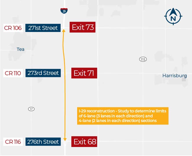
Project Area Map
Click to enlarge.
Presentation Overview Video
Meeting Recording
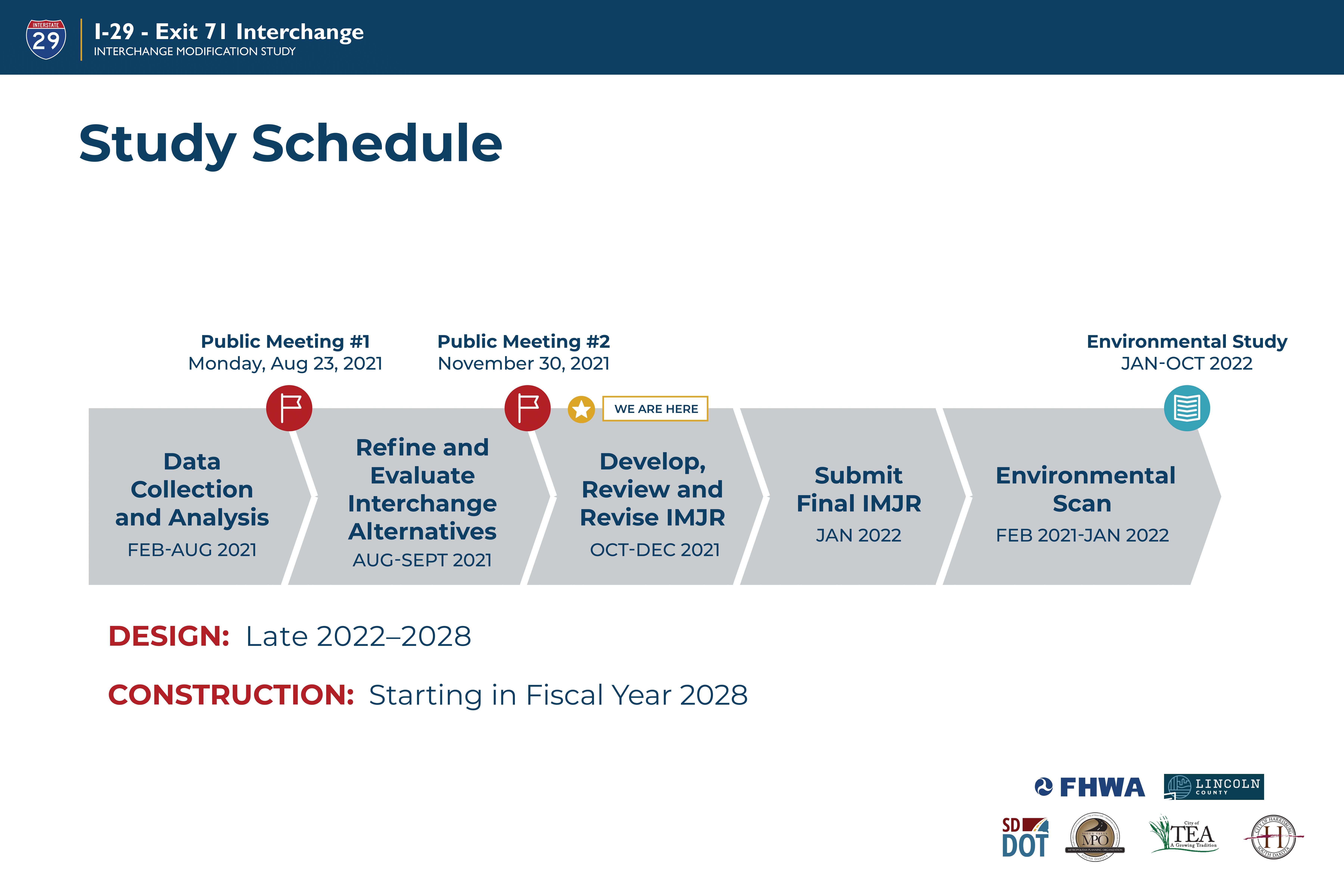
Study Schedule
Click to enlarge.
Study Area Data
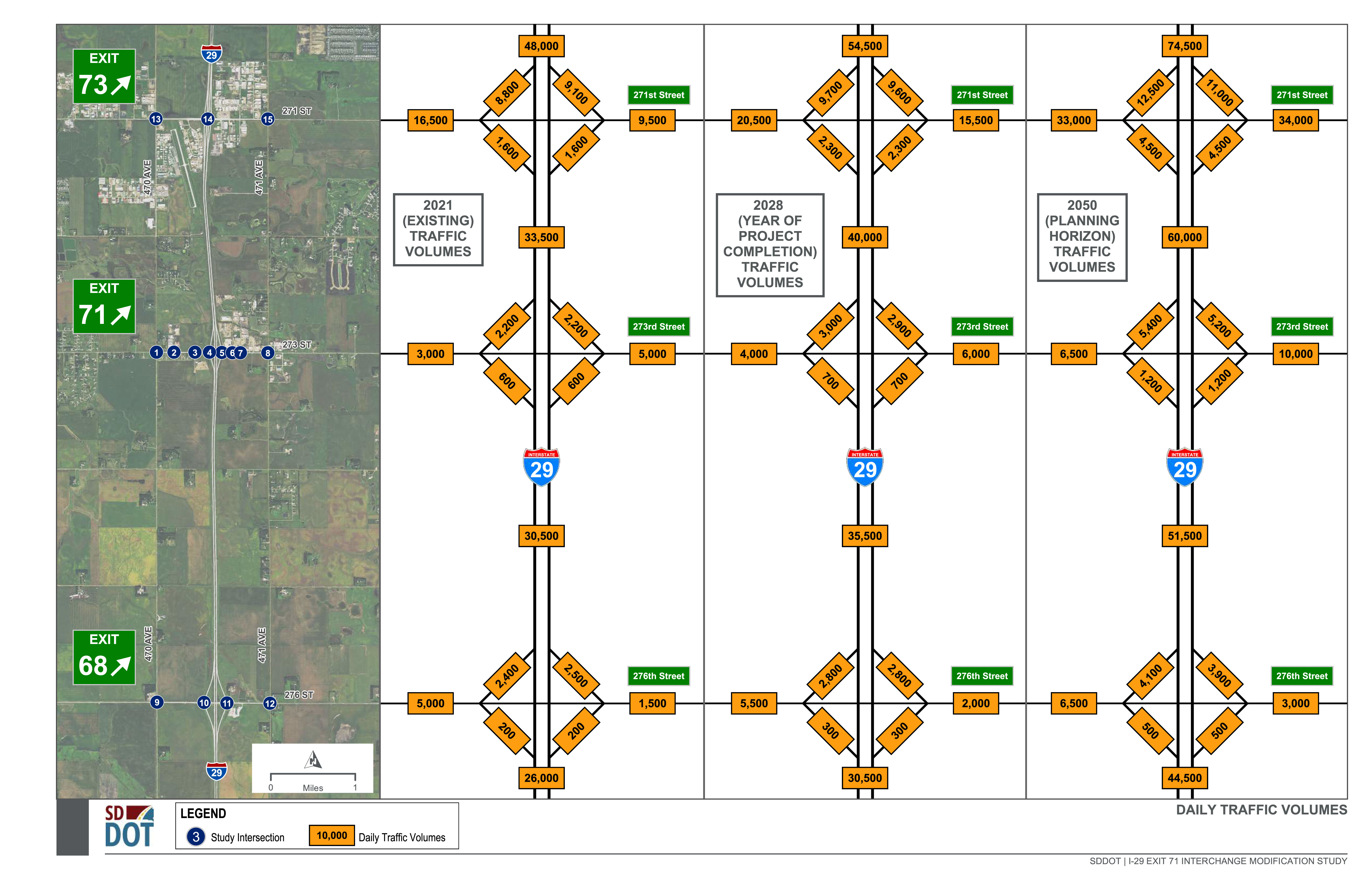
Study Traffic Volumes
Daily and peak hour (morning and afternoon commute periods) traffic volumes were developed for three analysis scenarios:
- Existing conditions (2021 traffic counts)
- 2028 Year of Project Completion
- 2050 Planning Horizon
The two future-year scenarios account for expected increases in traffic volumes passing through the study area and anticipated development.
Click to enlarge.
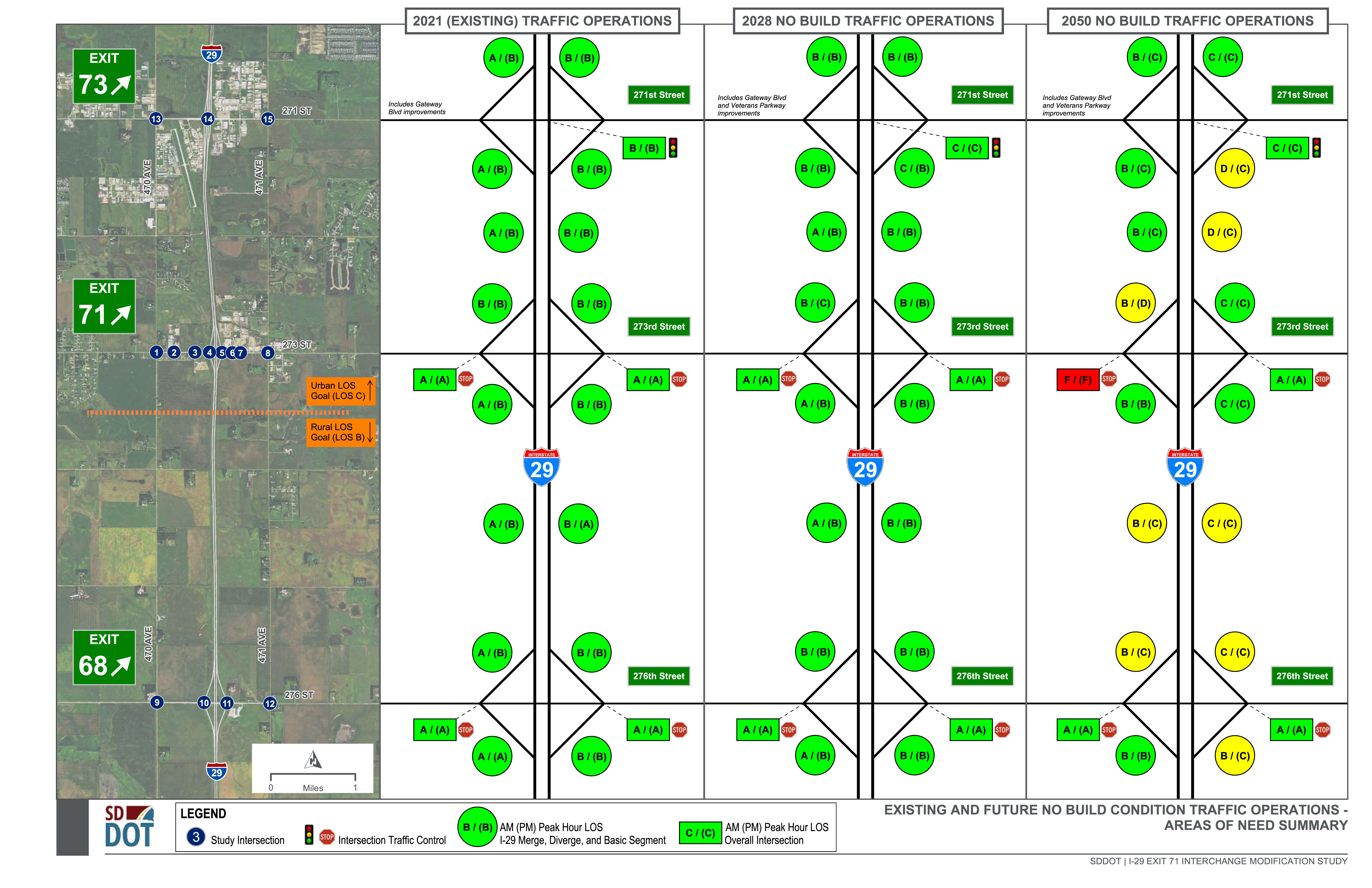
Study Area Traffic Operations Analysis
Using the existing and forecasted traffic volumes, study area intersections and roadway segments were analyzed to identify future capacity improvement needs in terms of Level of Service (LOS).
Click to enlarge.
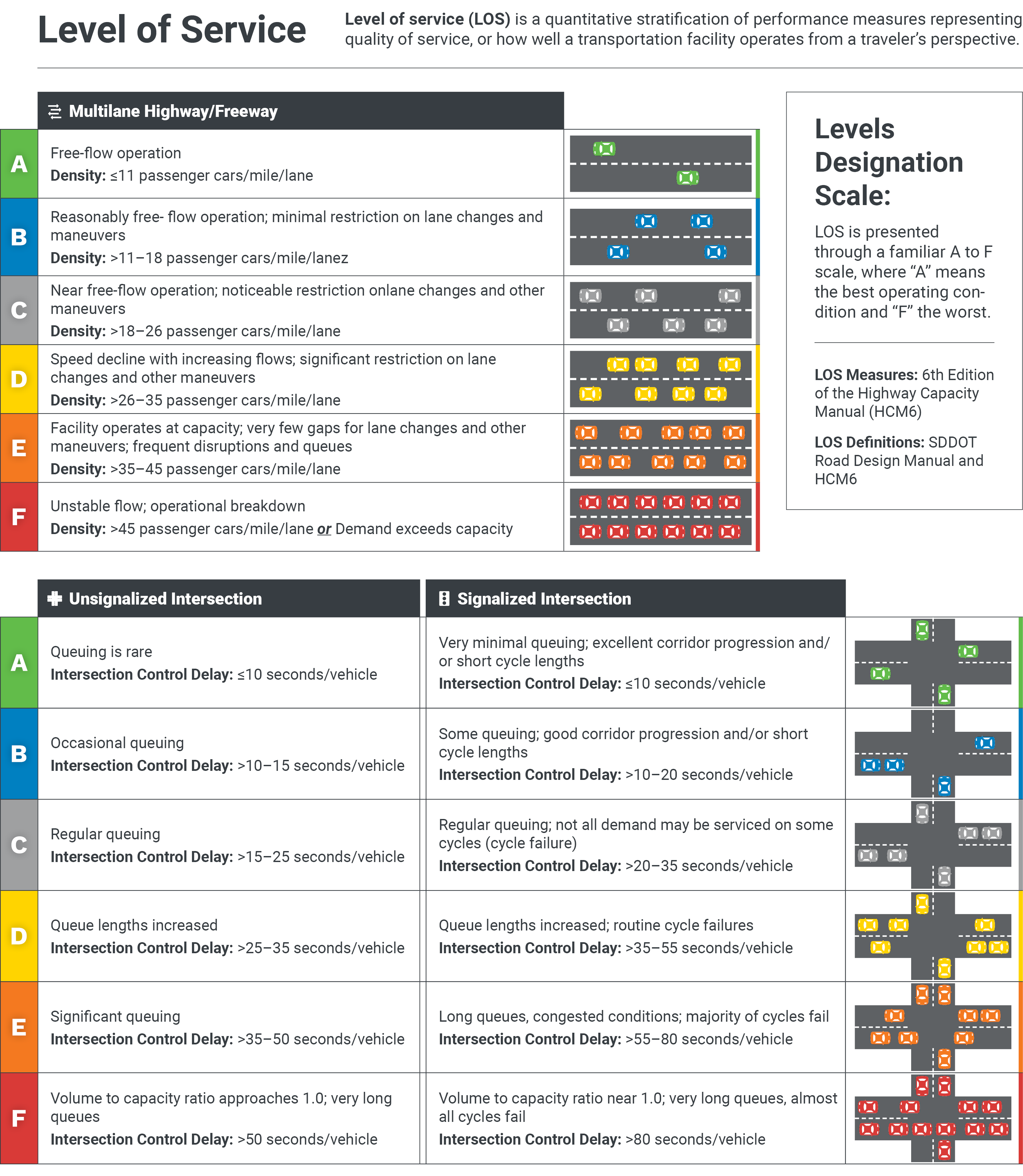
LOS Definitions
Level of service (LOS) is a quantitative stratification of performance measures representing quality of service, or how well a transportation facility operates from a traveler’s perspective.
Click to enlarge.
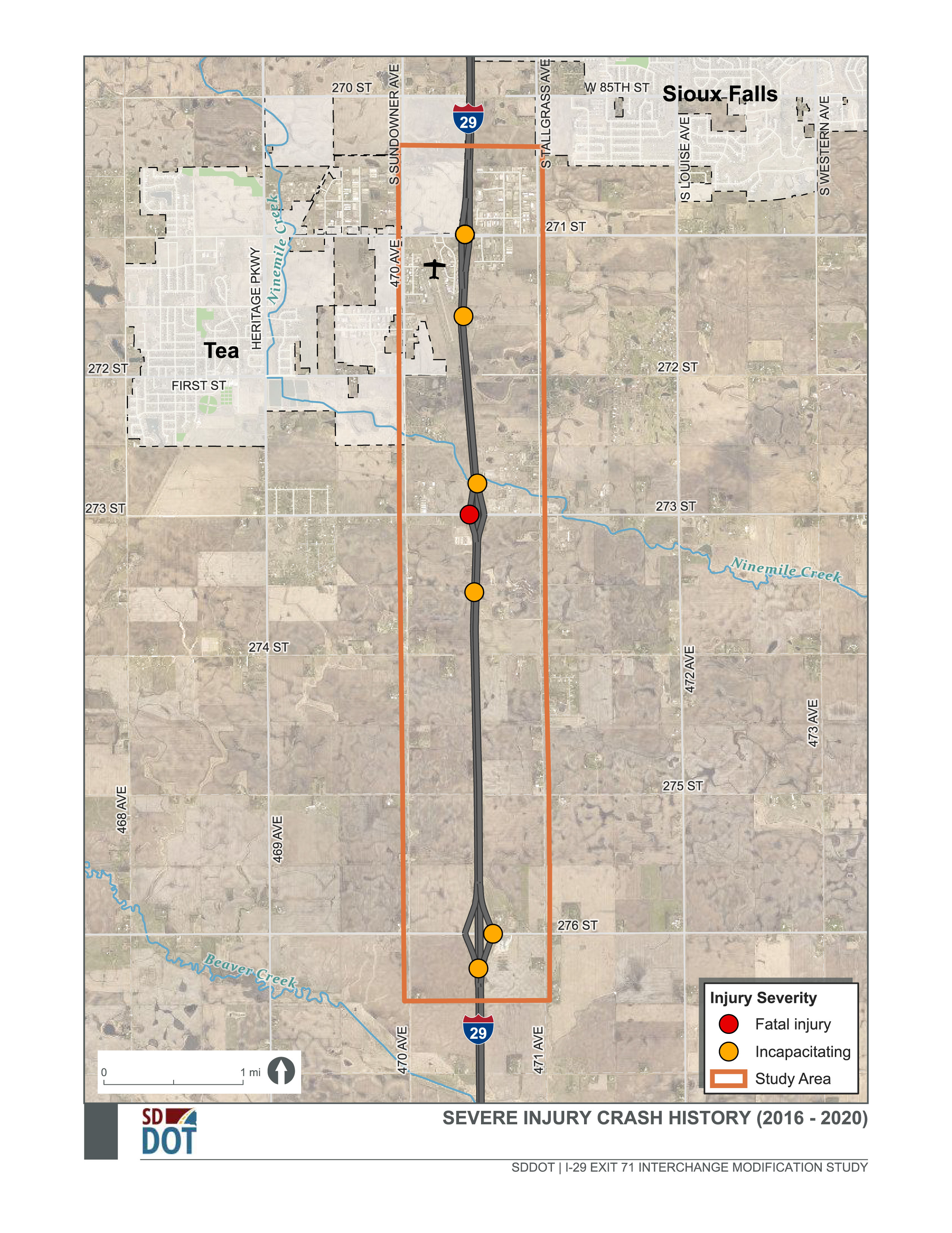
Study Area Crash History (2016 – 2020)
I-29 Exit 71 Southbound Ramp Terminal Intersection: 4 crashes
- One fatality and one serious injury
- 3 of 4 crashes were angle type crashes
- Sight distance limitations supports future interchange improvements
Click to enlarge.
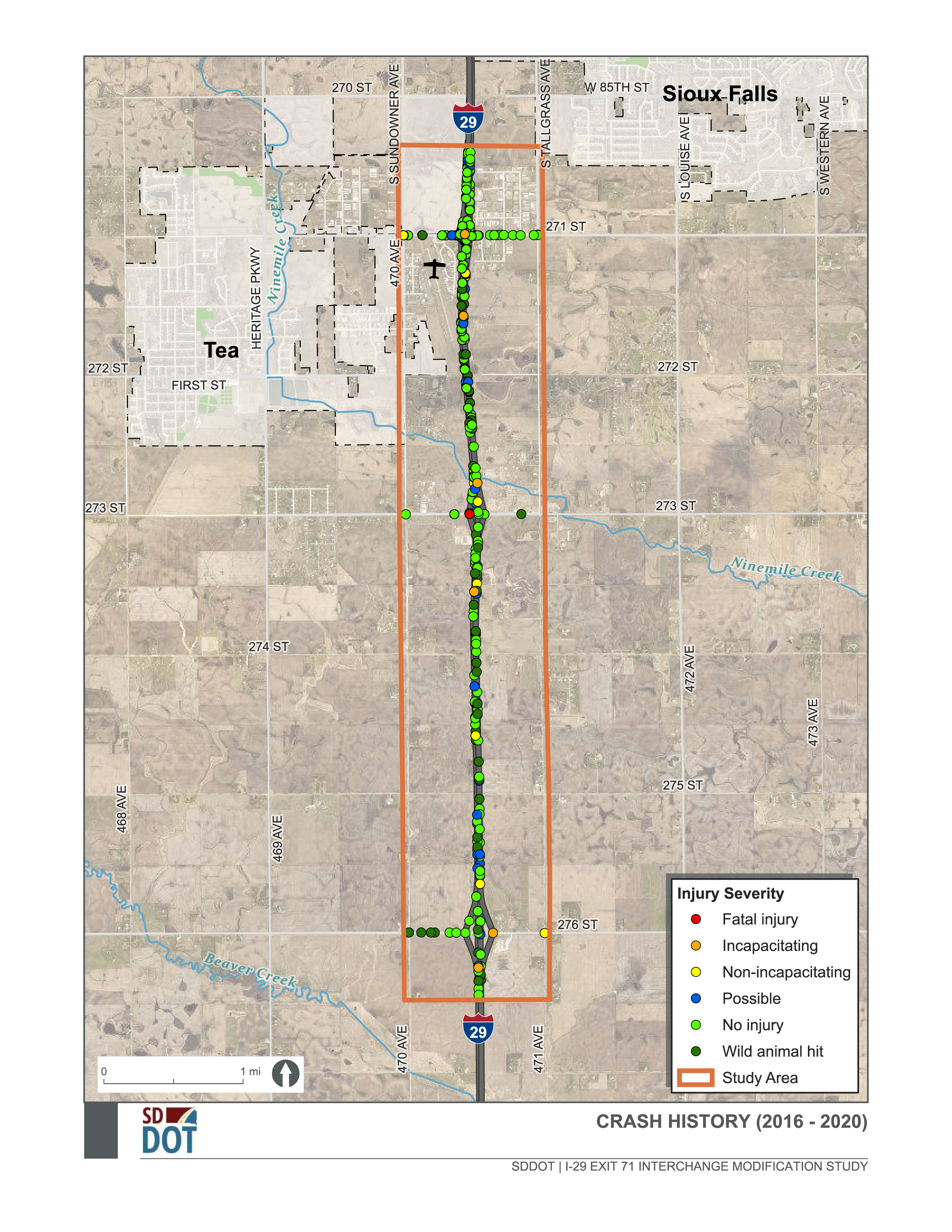
I-29 Mainline:
134 crashes
- 0 fatal crashes and 1 serious injury crash
- 25% of I-29 crashes were rear-end crashes
- 2x the percentage of rear-end crashes for I-29 statewide (12% of crashes were rear-end)
Click to enlarge.
Environmental Resources
This map shows some of the known resources adjacent to the I-29/Exit 71 Interchange project area. In the upcoming months, the project team will be conducting more detailed field studies to analyze and minimize impacts to biological, cultural, and socioeconomic resources such as:
- Historic Properties
- Farmland
- Wetlands and Streams
- Threatened and Endangered Species
- Visual Resources
- Noise
- Floodplain
- Land Use
Click to enlarge.
CDI Alternatives
Compressed Diamond Interchange Alternatives
Interchange Overview
The I-29 Exit 71 compressed diamond interchange alternatives consist of:
- Similar interchange type and footprint to what is out there today
- Full reconstruction of interchange (ramps, 273rd Street, and bridge)
- Two options: I-29 under and I-29 over 273rd Street
- Intersections could open as stop-control (stop signs on the ramps) and then signalized when warranted by traffic volumes
- 273rd Street expanded to 3-lane section with turn lanes and access management
Interchange Alternatives
Compressed Diamond Interchange – I-29 Under
Click to enlarge.
- Year 2050 Level of Service (LOS)
- Interchange: LOS A
- Ramp Terminal Intersections: LOS B or better
- Least vehicular delay of the three interchange types
- Construction and ROW cost: $20.5 million
- Least cost of all interchange alternatives
- Opportunity to maintain traffic on 273rd Street across I-29 during construction
Compressed Diamond Interchange – I-29 Over
Click to enlarge.

- Year 2050 Level of Service (LOS)
- Interchange: LOS A
- Ramp Terminal Intersections: LOS B or better
- Least delay of the three interchange types
- Construction and ROW cost: $25 million
- Potential impacts to WAPA transmission lines (which would increase cost)
- 273rd Street closed across I-29 during construction
SPI Alternatives
Single Point Interchange Alternatives
Interchange Overview
The I-29 Exit 71 SPI alternatives consist of:
- Single, signalized interchange intersection
- Full reconstruction of interchange (ramps, 273rd Street, and bridge)
- Two options: I-29 under and I-29 over 273rd Street
- 273rd Street expanded to 3-lane section with turn lanes and access management
Interchange Alternatives
SPI – I-29 Under
Click to enlarge.
- Year 2050 Level of Service (LOS)
- Interchange: LOS B
- Ramp Terminal Intersection: LOS C or better
- Greatest vehicular delay of the three interchange types
- Construction and ROW cost: $33 million
- Greatest cost of all interchange alternatives
- Opportunity to maintain traffic on 273rd Street across I-29 during construction
- Greatest separation between interchange and next adjacent local intersections
SPI – I-29 Over
Click to enlarge.
- Year 2050 Level of Service (LOS)
- Interchange: LOS B
- Ramp Terminal Intersection: LOS C or better
- Greatest vehicular delay of the three interchange types
- Construction and ROW cost: $29.5 million
- Potential impacts to WAPA transmission lines (which would increase cost)
- 273rd Street closed across I-29 during construction
- Greatest separation between interchange and next adjacent local intersections
DDI Alternatives
Diverging Diamond Interchange Alternatives
Interchange Overview
The I-29 Exit 71 DDI alternatives consist of:
- Two signalized crossover intersections at each of the ramp terminals that cross over traffic to the opposite side of the roadway through the interchange
- Full reconstruction of interchange (ramps, 273rd Street, and bridge)
- Two options: I-29 under and I-29 over 273rd Street
- Layouts reflect 273rd Street expansion to a 4-lane section (two through lanes in each direction), but interchange could open with a single through lane in each direction plus turn lanes
Interchange Alternatives
DDI – I-29 Under
Click to enlarge.
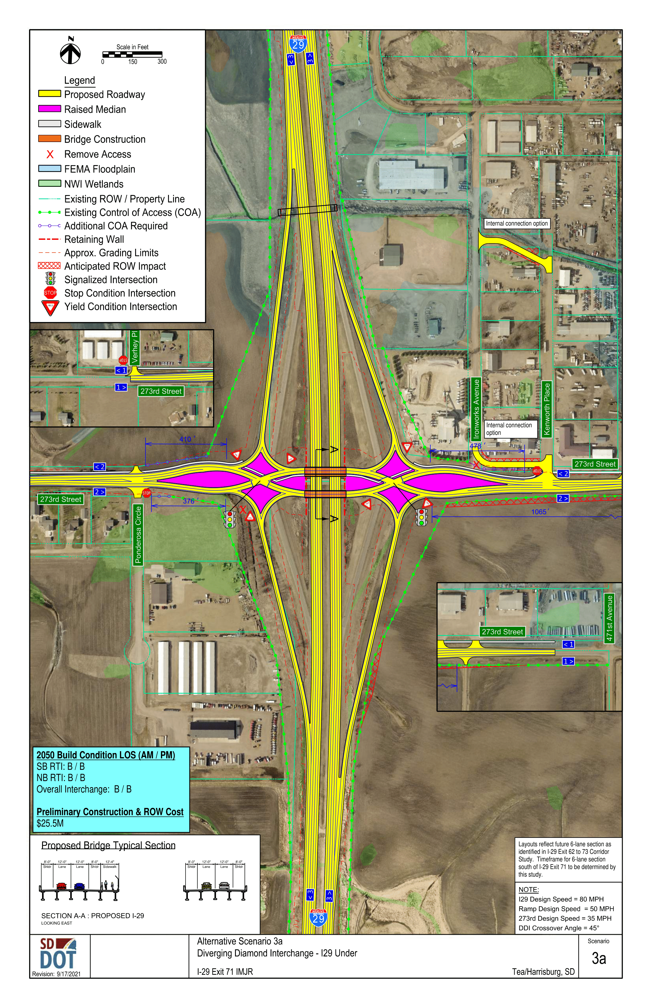
- Year 2050 Level of Service (LOS)
- Interchange: LOS B
- Ramp Terminal Intersection: LOS B
- Construction and ROW cost: $25.5 million
- Opportunity to maintain traffic on 273rd Street across I-29 during construction
DDI – I-29 Over
Click to enlarge.
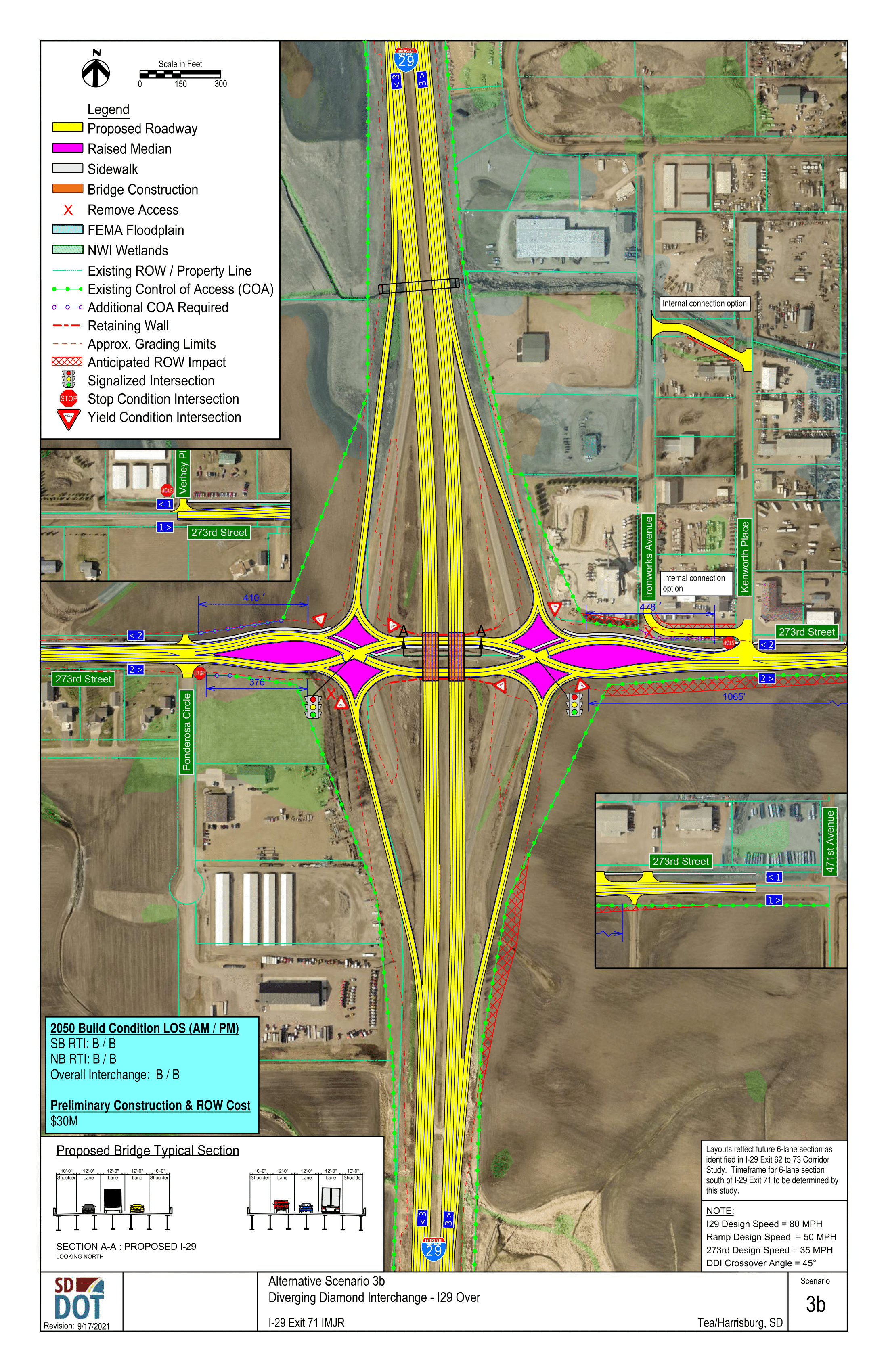
- Year 2050 Level of Service (LOS)
- Interchange: LOS B
- Ramp Terminal Intersection: LOS B
- Construction and ROW cost: $30 million
- Potential impacts to WAPA transmission lines (which would increase cost)
- 273rd Street closed across I-29 during construction
Interchange Alignment Options
The 273rd Street corridor was further evaluated with varying degrees of southward alignment shift through the interchange to address the following goals:
- Construct new 273rd Street bridge off alignment to maintain traffic on existing bridge during construction
-
Increase separation between 273rd Street and a potential frontage road at
Kenworth Place to provide for:
- Rocky Mountain Double truck turning movements: eastbound frontage road to westbound 273rd Street
- Southbound Kenworth Place queue storage: greater separation provides reduced risk of southbound Kenworth Place queues blocking northbound Kenworth Place (turning from 273rd Street) access to the frontage road
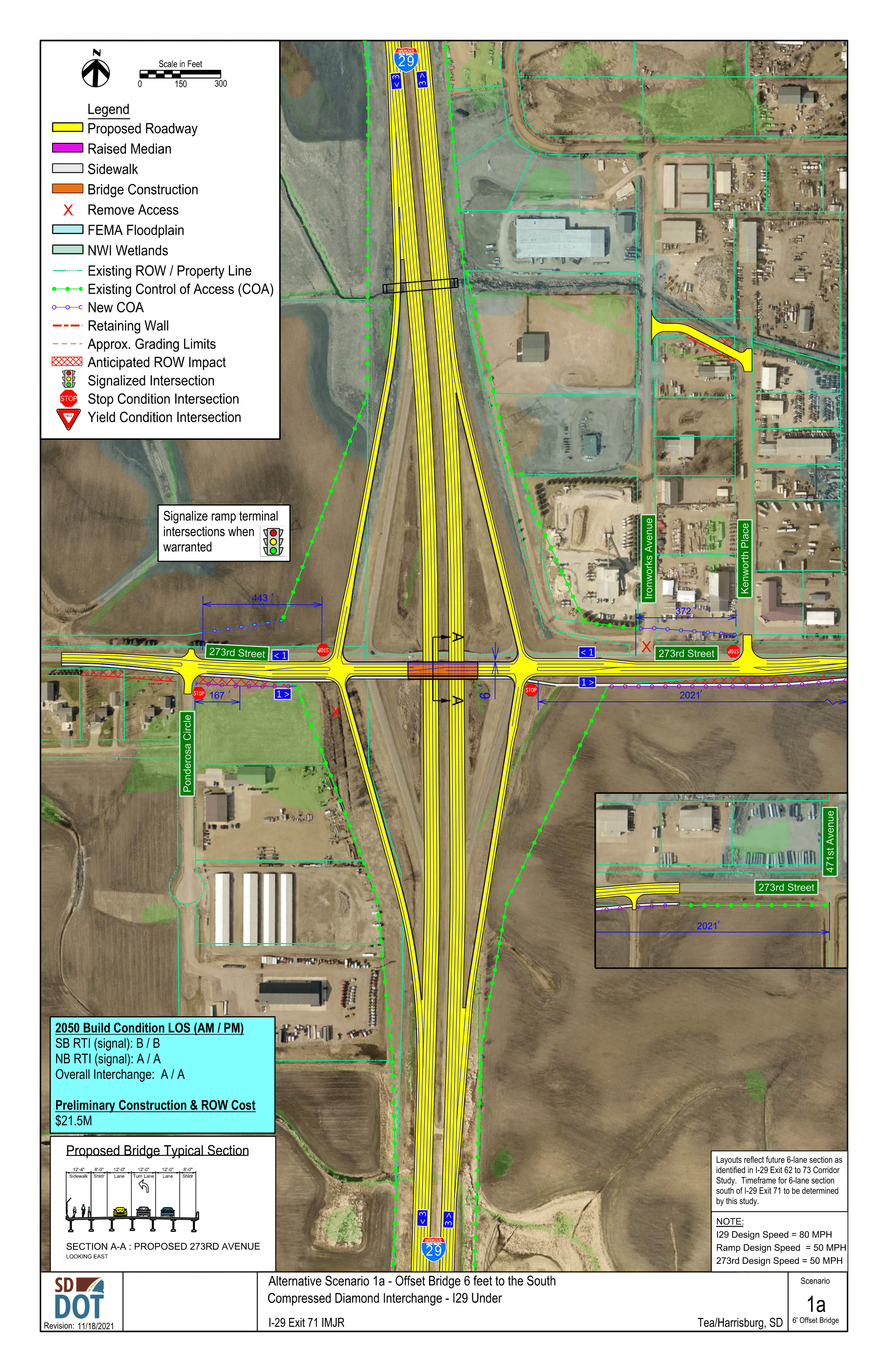
The following options were developed for the Compressed Diamond interchange (I-29 under) alternative but have elements applicable to all interchange type.
Option 1: 6’ Offset
New bridge constructed 6’ south of existing bridge
Click to enlarge.
Option 2: 55’ Offset
New bridge constructed 55’ south of existing bridge
Click to enlarge.

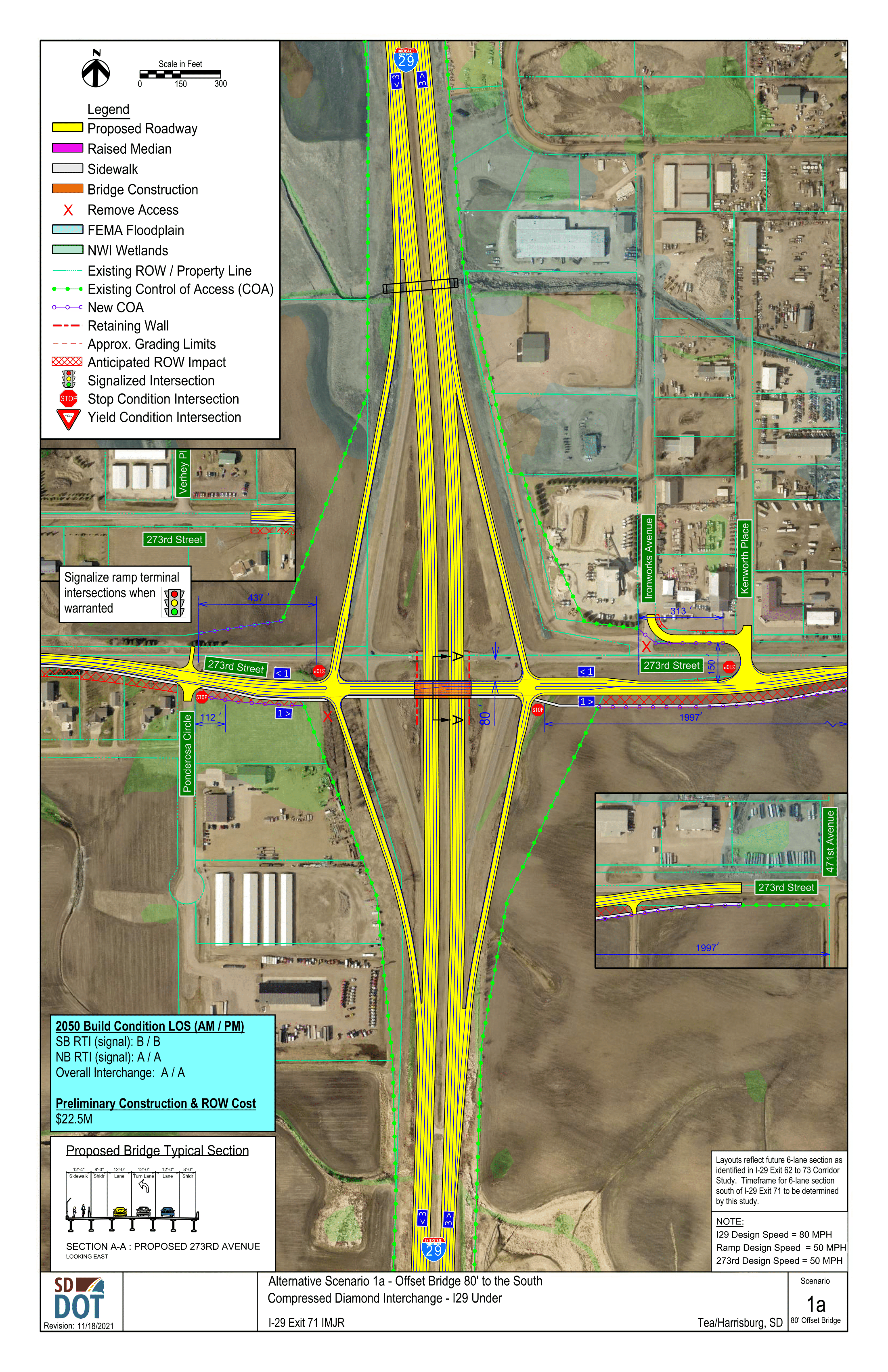
Option 3: 80’ Offset
New bridge constructed 80’ south of existing bridge
Click to enlarge.
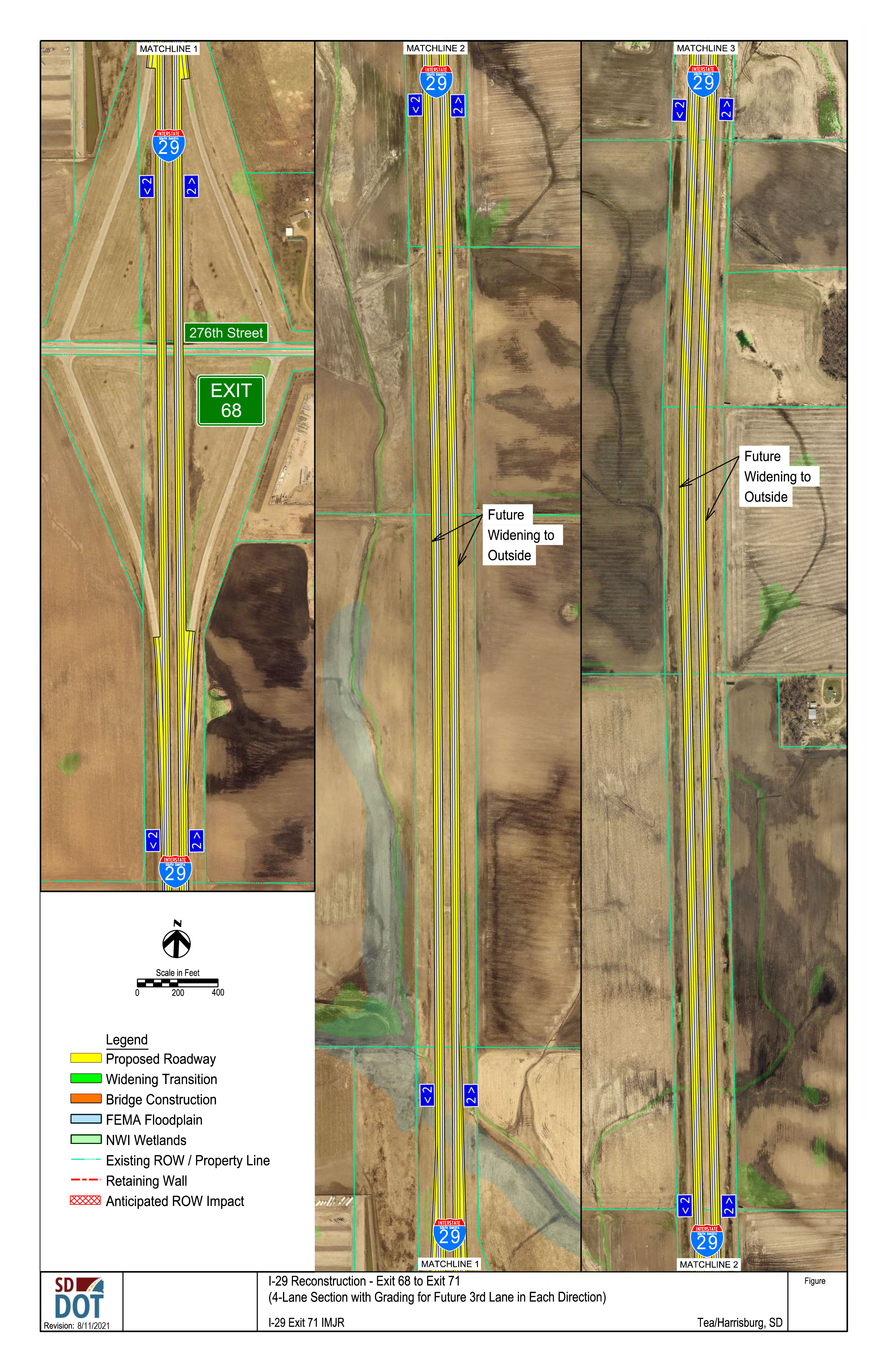
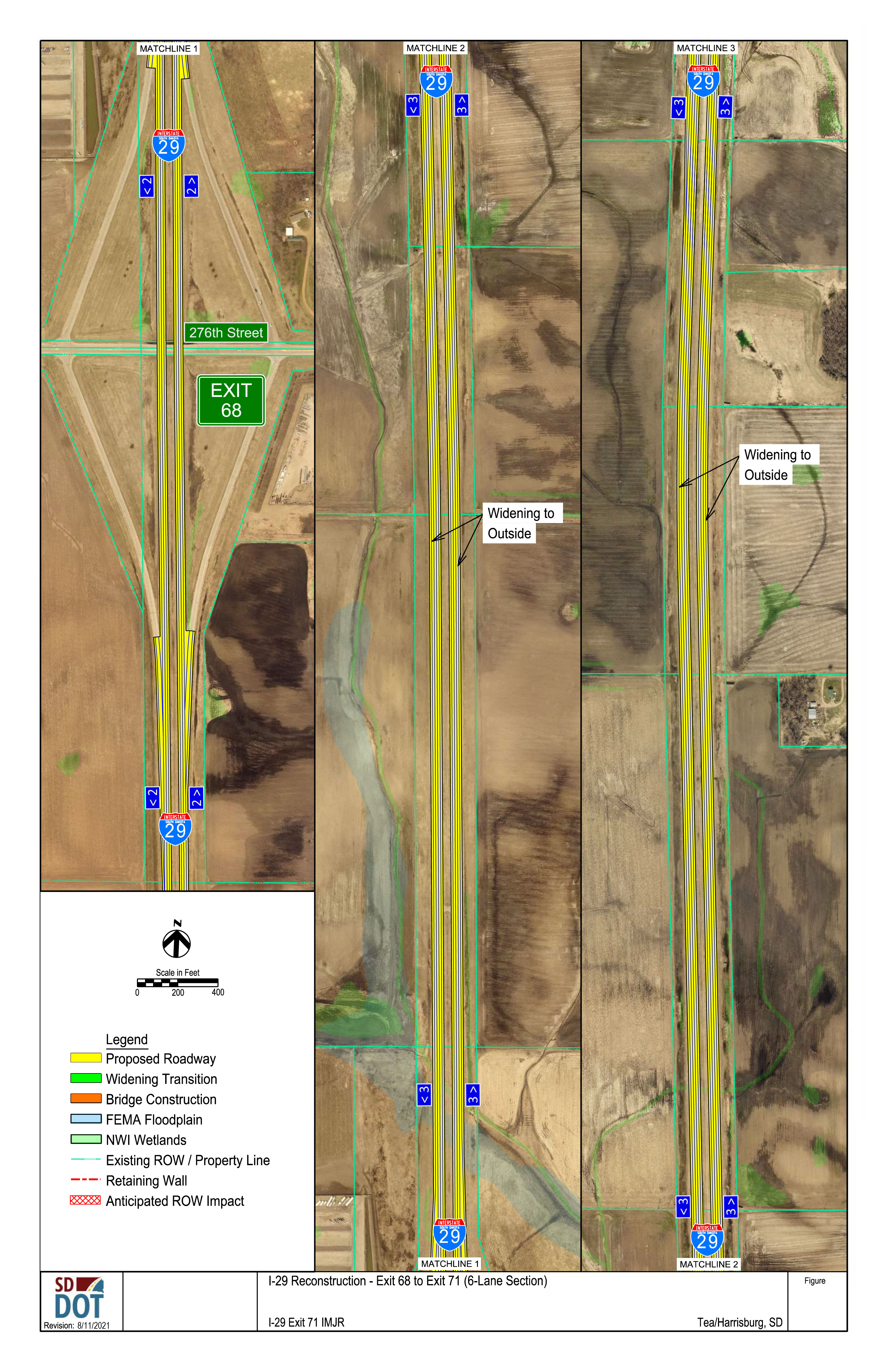
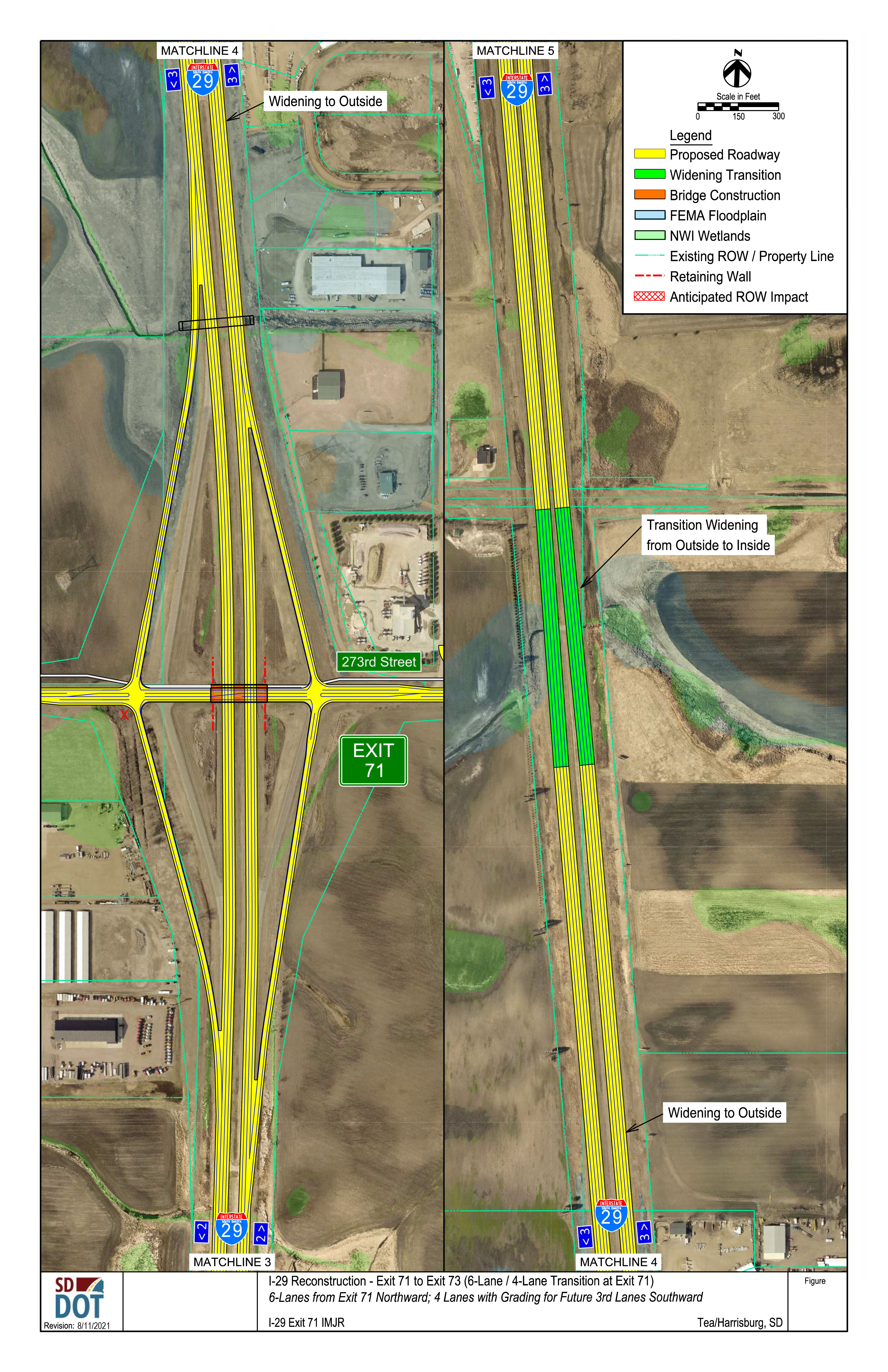
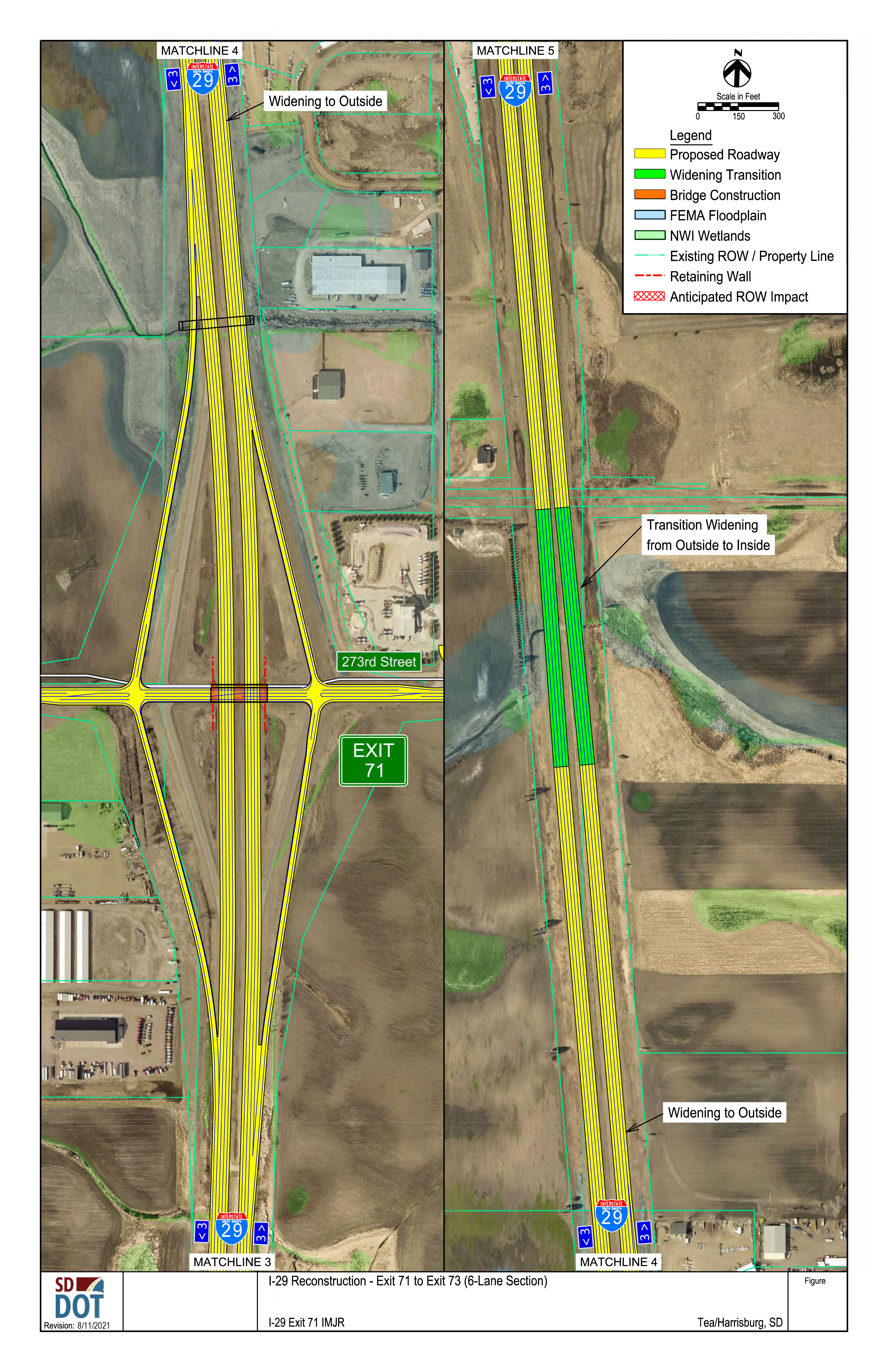
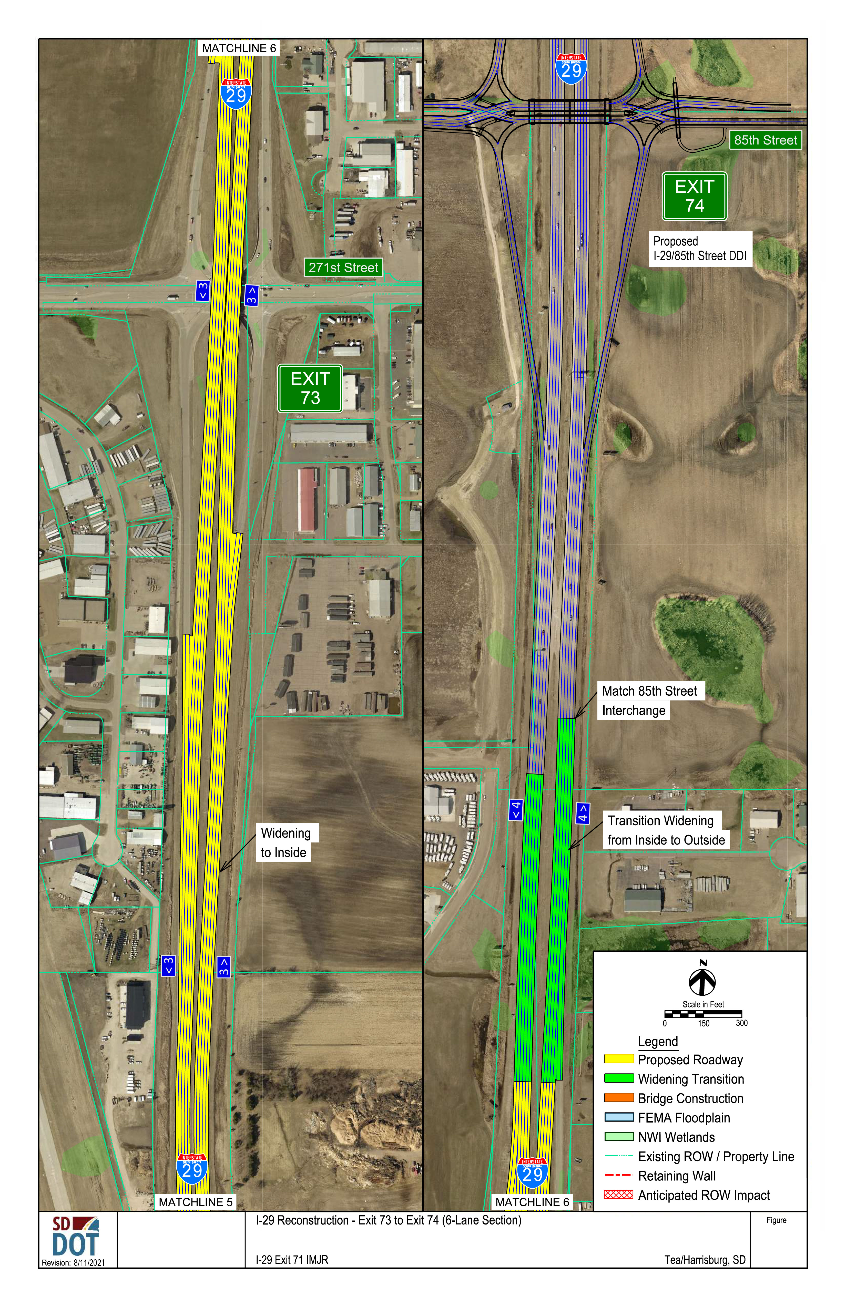
I-29 Mainline Alternatives
SDDOT is planning to reconstruct I-29 through the study area as part of the I-29 Exit 71 interchange project. Preliminary plans include:
- Expanding I-29 to 6 lanes (3 lanes in each direction) from I-29 Exit 71 northward
- Reconstructing I-29 with 4 lanes (2 lanes in each direction) from I-29 Exit 71 southward to Exit 68
- Grading would include space for a future 3rd lane in each direction
- The 3rd lane in each direction would likely be added by Year 2050
One of this study’s goals is to determine whether I-29 through and south of Exit 71 needs to include all 6 lanes with the interchange project or whether the preliminary plan of paving 4 lanes now and adding the 3rd lane in each direction when needed will meet future needs.
Click the images below to enlarge.
Exit 68 to Exit 71 (4-lane)
Exit 68 to Exit 71 (6-lane)
Exit 71 to Exit 73 (6-lane to 4-lane transition)
Exit 71 to Exit 73 (6 lane)
Exit 73 to Exit 74 (6 lane)
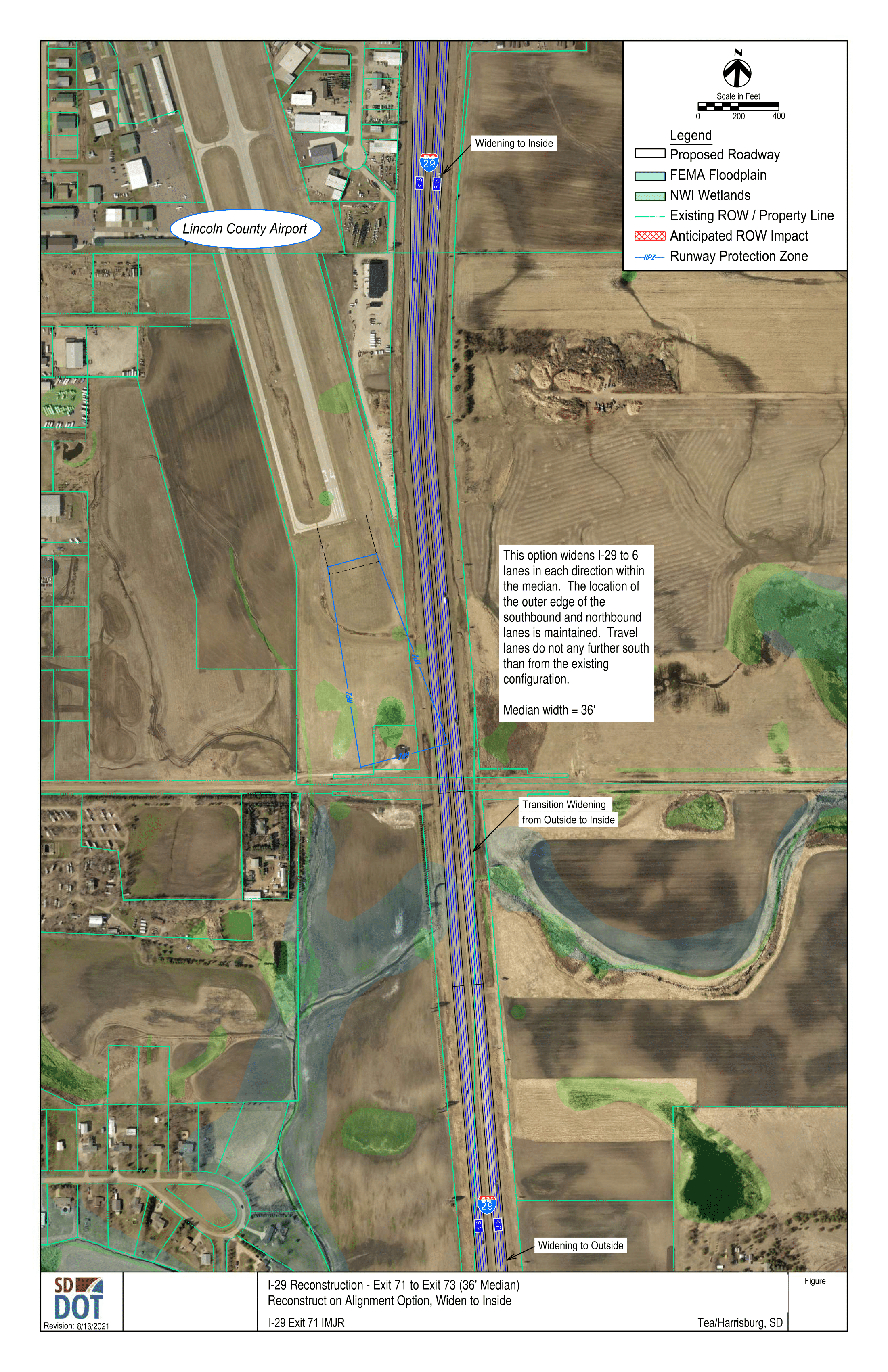
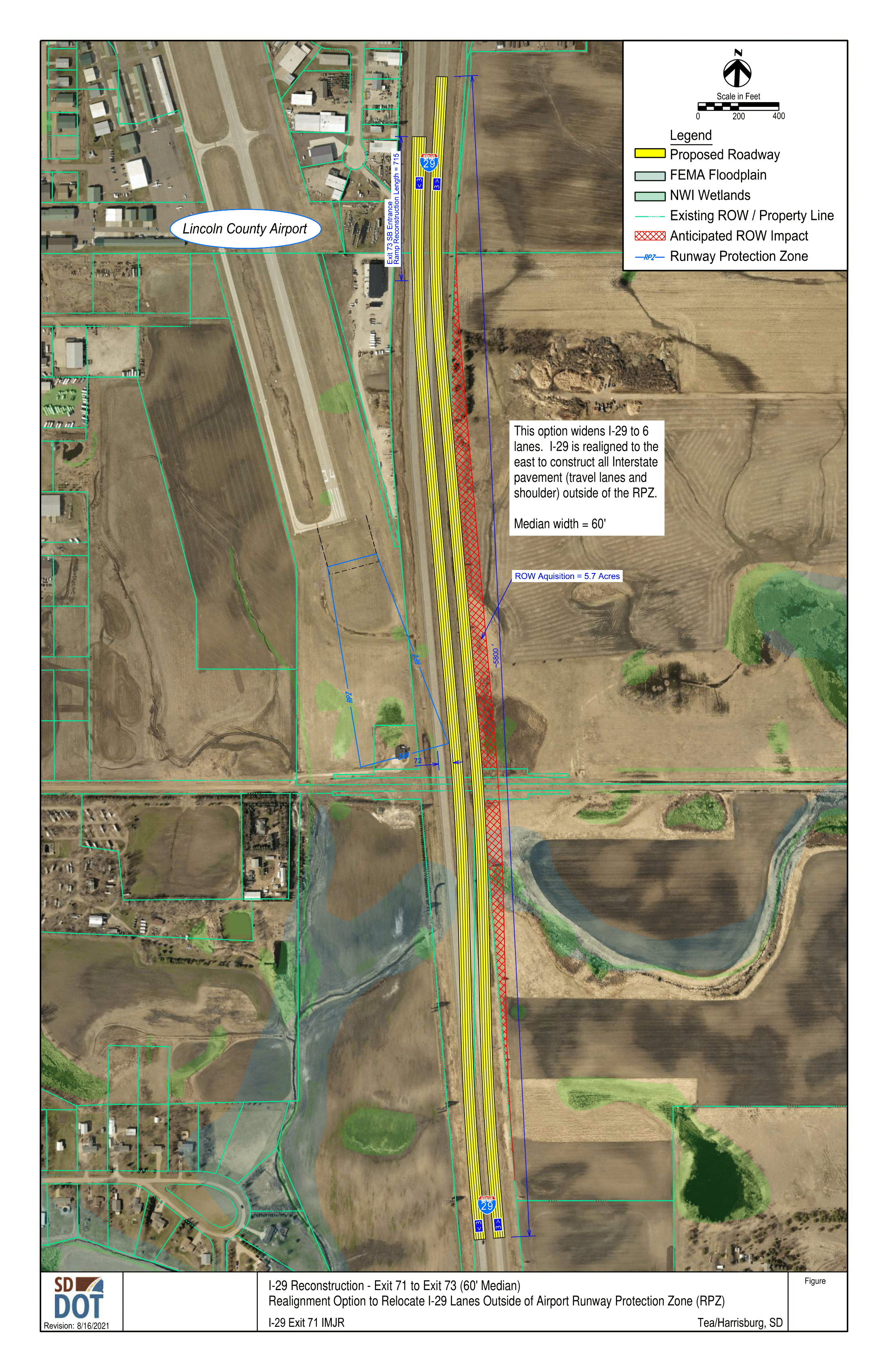
Airport Runway Protection Zone Avoidance Options
Option 1
Reconstructs I-29 on the existing alignment with the new
3rd lane in each direction added to the inside median.
New median width is 36’.
Click to enlarge.
Option 2
Realign I-29 outside of the RPZ to the east. Exhibits a
36’ median width to match I-29 to the north
Click to enlarge.

Option 3
Realign I-29 outside of the RPZ to the east. Exhibits a
60’ median width to match I-29 to the south.
Click to enlarge.
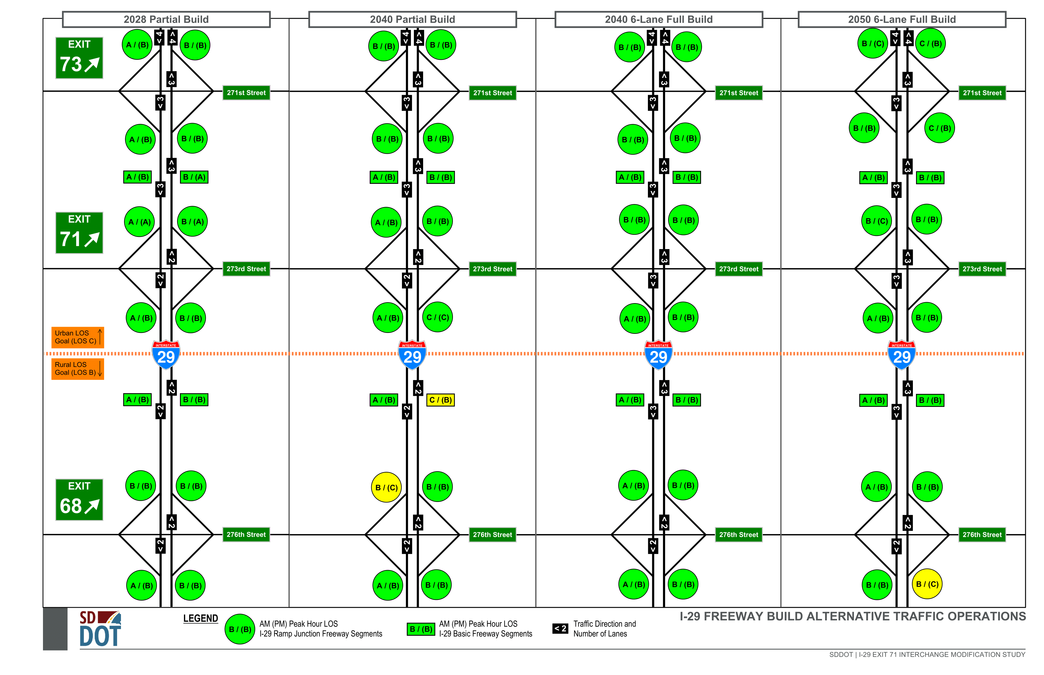
I-29 Mainline Evaluation
Interchange Mainline Evaluation and Preliminary Recommendations
Traffic Operations (Level of Service, LOS)
LOS-based conclusions on number of lanes required to address capacity needs (see figure):
-
Exit 73 to planned 85th Street interchange: 4 lanes in
each direction
- Auxiliary lane connecting ramps needed due to spacing
- Exit 71 northward through Exit 73: 3 lanes in each direction
-
Exit 68 northward through Exit 71: 3 lanes in each
direction (‘Full Build’ option)
- ‘Partial Build’ (2 lanes in each direction): two segments do not meet study LOS B goal in Year 2040
Click to enlarge.
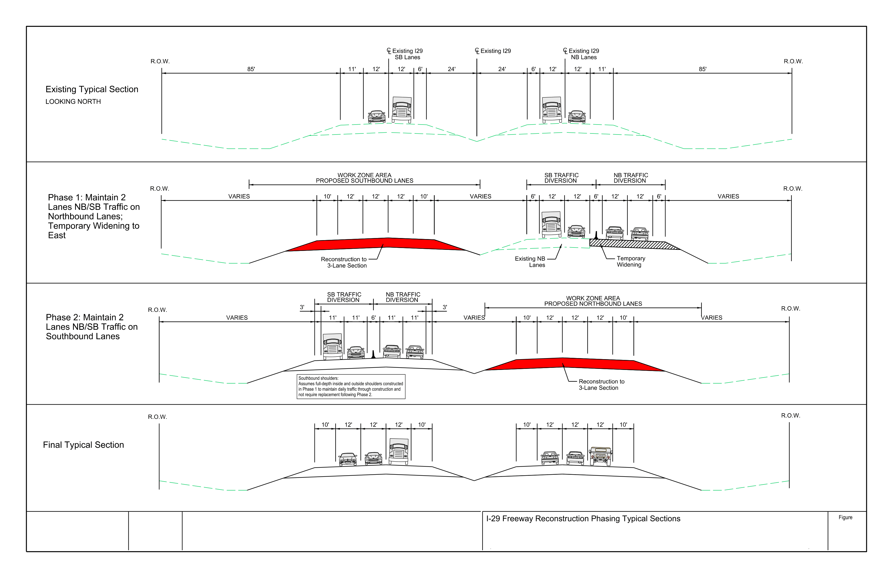
Maintenance of Traffic during Construction
I-29 work zone capacity and reliability analyses demonstrated a need or benefit to maintaining a minimum number lanes in both directions during:
- Exit 71 northward: 2 lanes required
- Exit 71 southward: 2 lanes beneficial, as a single lane in each direction poses risk of congestion during peak traffic periods
Proposed I-29 phasing reflects a similar approach to I-29 reconstruction between Exit 73 and I-229 interchange, where one side is reconstructed and the other maintains two lanes of traffic in each direction.
Click to enlarge.
Construction/Constructability (Exit 71 and South)
Benefits to constructing the full 6-lane section from Exit 71 southward, in lieu of 2 lanes in each direction with the 3rd lane deferred until a later date, include:
- Economies of scale and less duplicate work with a single project
- Less temporary pavement and traffic control
- Worker safety with traffic and work areas separate
- Future addition of a third lane would be adjacent to work zone traffic
Further, by maintaining two lanes of traffic in each direction, constructing a 4-lane section one half at a time would nearly build-out the full 3 southbound lanes in the first phase.
Recommendations:
The following lane configuration is recommended to be constructed as part of the planned 2028 project:
- North of Exit 73: 3 through lanes plus auxiliary lane between interchanges
- Exit 73: 3 through lanes
- Exit 71 to Exit 73: 3 through lanes
- Exit 71: 3 through lanes
- Exit 68 to Exit 71: 3 through lanes
The recommended I-29 alignment option between Exit 68 and Exit 71 will be determined through coordination with Federal Aviation Administration.
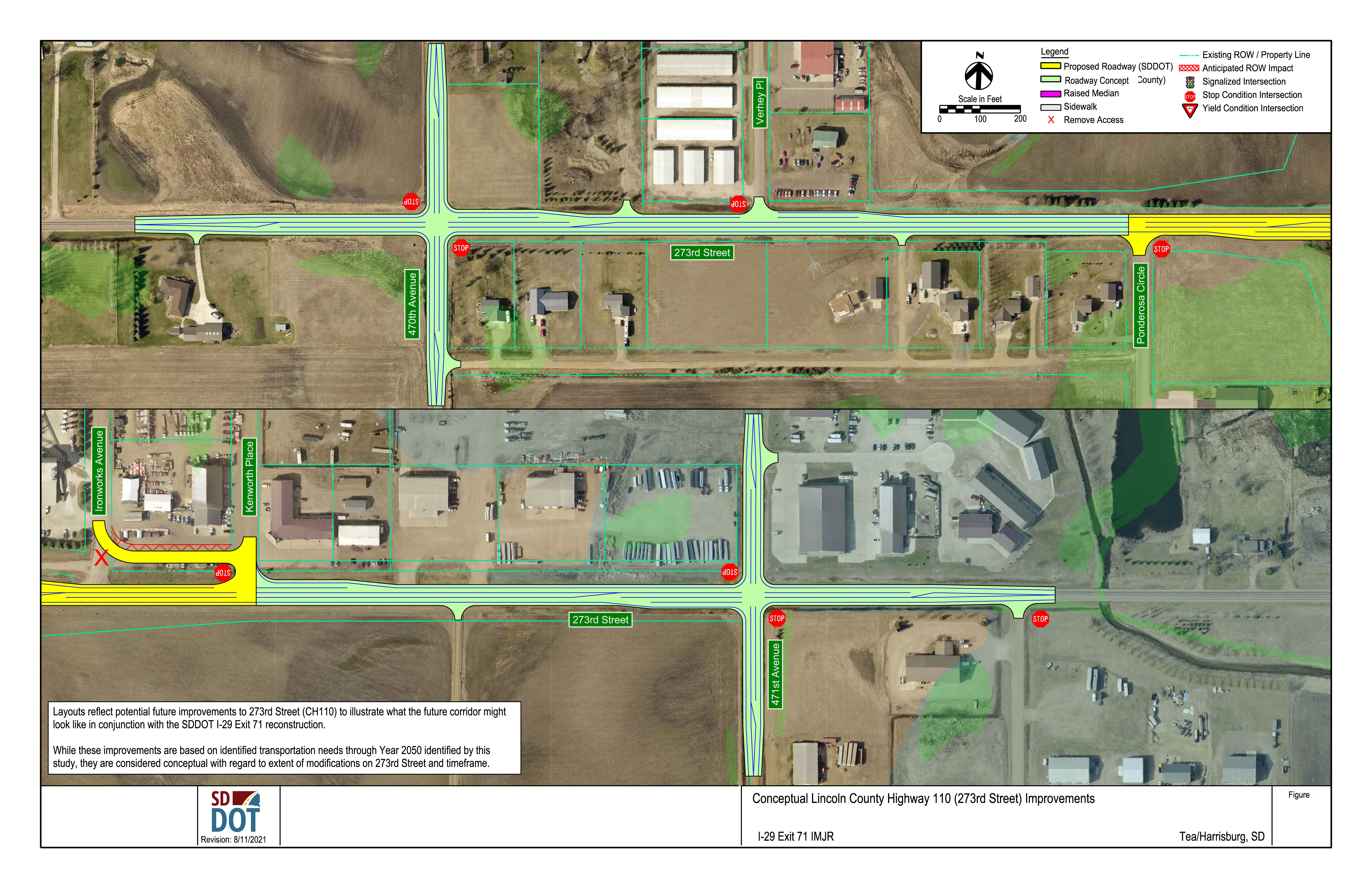
273rd Street Concepts
The 273rd Street (Lincoln County Highway 110) conceptual layouts reflect potential future improvements to illustrate what the future corridor might look like in conjunction with the planned SDDOT I-29 Exit 71 reconstruction. While these improvements are based on identified transportation needs through this study’s 2050 Planning Horizon, they are considered conceptual with regard to extent of modifications on 273rd Street and implementation timeframe.
Click to enlarge.
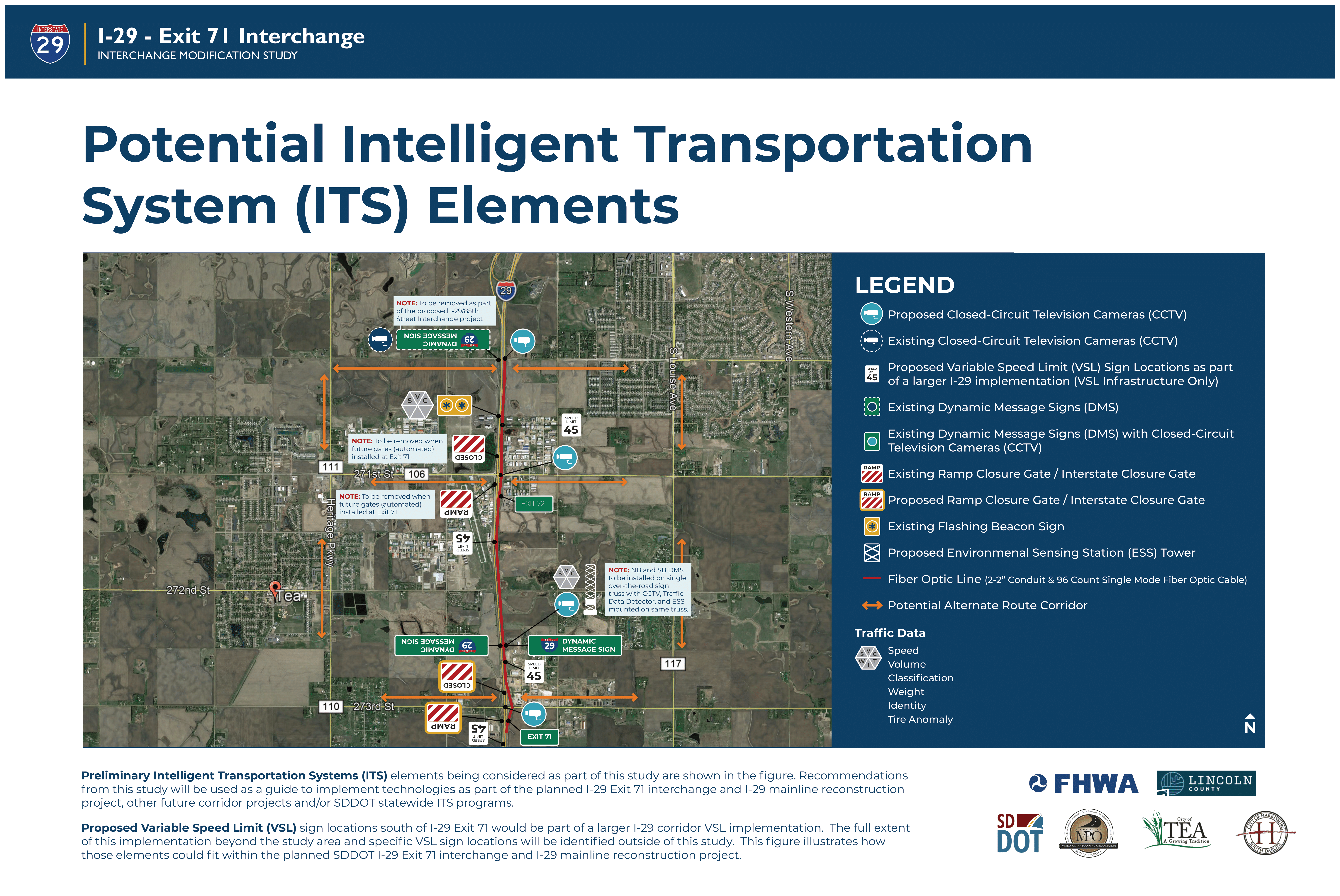
Potential ITS Elements
Preliminary ITS elements being considered as part of this study are shown in the figure. Recommendations from this study will be used as a guide to implement technologies as part of the planned I-29 Exit 71 interchange and I-29 mainline reconstruction project, other future corridor projects and/or SDDOT statewide ITS programs.
Potential ITS Map
Preliminary Intelligent Transportation Systems (ITS) elements being considered as part of this study are shown in the figure. Recommendations from this study will be used as a guide to implement technologies as part of the planned I-29 Exit 71 interchange and I-29 mainline reconstruction project, other future corridor projects and/or SDDOT statewide ITS programs.
Proposed Variable Speed Limit (VSL) sign locations south of I-29 Exit 71 would be part of a larger I-29 corridor VSL implementation. The full extent of this implementation beyond the study area and specific VSL sign locations will be identified outside of this study. This figure illustrates how those elements could would fit within the planned SDDOT I-29 Exit 71 interchange and I-29 mainline reconstruction project.
Click to enlarge.
Stay Connected
Thank you for your participation!
Leave a Comment
The comment period for this meeting has ended. If you would like to leave a general comment, please use the comment form on the project website.
Mark Your Calendar
This will be the final public meeting of the Interchange Modification Study if the National Environmental Policy Act (NEPA) classification is determined to be a Categorical Exclusion (CE). If an Environmental Assessment (EA) is required, a third public meeting will be held during the summer/fall 2022.
Project Contacts
Questions for the project team?
Jon Wiegand, P.E., PTOE, Consultant Project
Manager
jonathan.wiegand@hdrinc.com | 605-782-8105
Steve Gramm, P.E., SDDOT Project Manager
steve.gramm@state.sd.us | 605-773-3281